Dunwoody's nine main areas, from Perimeter to Winters Chapel: ZIP codes, zoned schools and August 2026 Zillow home values for each, with a map.
Last checked Oct. 5, 2026. Sources: the City of Dunwoody’s 2025-2045 Comprehensive Plan (PDF) and open GIS data, the DeKalb County School District school locator map data, the state’s 2025 School Grades data, Zillow Research, the Census Bureau and OpenStreetMap.
Dunwoody is a city of 51,758 people in the northwest corner of DeKalb County, according to the Census Bureau’s 2020-2024 American Community Survey five-year estimates. Its city limits cover about 13 square miles, by the city’s GIS boundary. Interstate 285 runs along the south side, with exits 29, 30 and 31, and Georgia 400 runs just west of the city line in Sandy Springs. Perimeter Center, with its office towers, Perimeter Mall and MARTA’s Dunwoody Station, fills the southwest corner; most of the rest is single-family neighborhoods.
Three things to know before you look at a listing:
- Most of the city is neighborhoods. The city’s 2025-2045 Comprehensive Plan says its Suburban Neighborhoods character area covers 70% of Dunwoody’s land, with most lots over a quarter acre. Apartments and condos are concentrated in Perimeter, Georgetown and on the east side.
- Three main ZIP codes. In the city’s address data, 66% of addresses are in 30338, 19% in 30346 and 14% in 30360. A few streets on the Sandy Springs line are in 30350.
- School zones do not follow city limits. Every Dunwoody address in the DeKalb County School District’s 2026-27 zone map, apart from a handful at the edges, is zoned for Dunwoody High and Peachtree Middle, but the Dunwoody High zone also covers about 1.8 square miles outside the city to the southeast. Elementary zones split the city six ways, and Hightower Elementary is outside the city line. Always check one address with the district’s school locator.
The areas at a glance
Elementary shares are of the area’s addresses in the city’s address data, matched to the district’s zone map on Oct. 5. Every area is zoned for Dunwoody High. Home values are the Zillow Home Value Index for August 2026: a modeled typical value for the middle third of homes in the whole ZIP code, not a sale price. The citywide figure was $672,389.
| Area | Main ZIP code | Elementary school (most addresses) | Typical value, main ZIP |
|---|---|---|---|
| Perimeter | 30346 | Dunwoody (85%) | $447,120 |
| Ashford | 30338 | Vanderlyn (88%) | $710,439 |
| Dunwoody Village | 30338 | Vanderlyn (87%) | $710,439 |
| Jett Ferry and Dunwoody Club Drive | 30338 | Austin (60%) | $710,439 |
| Vermack Road and Womack Road | 30338 | Dunwoody (73%) | $710,439 |
| Georgetown | 30338 | Chesnut (59%) | $710,439 |
| Brook Run and North Peachtree Road | 30338 and 30360 | Chesnut (77%) | $710,439 (30338) |
| Tilly Mill and Happy Hollow roads | 30338 and 30360 | Kingsley (97.5%) | $710,439 (30338) |
| Winters Chapel and Peachtree Boulevard | 30360 | Hightower (58%) | $503,274 |
Map of the areas
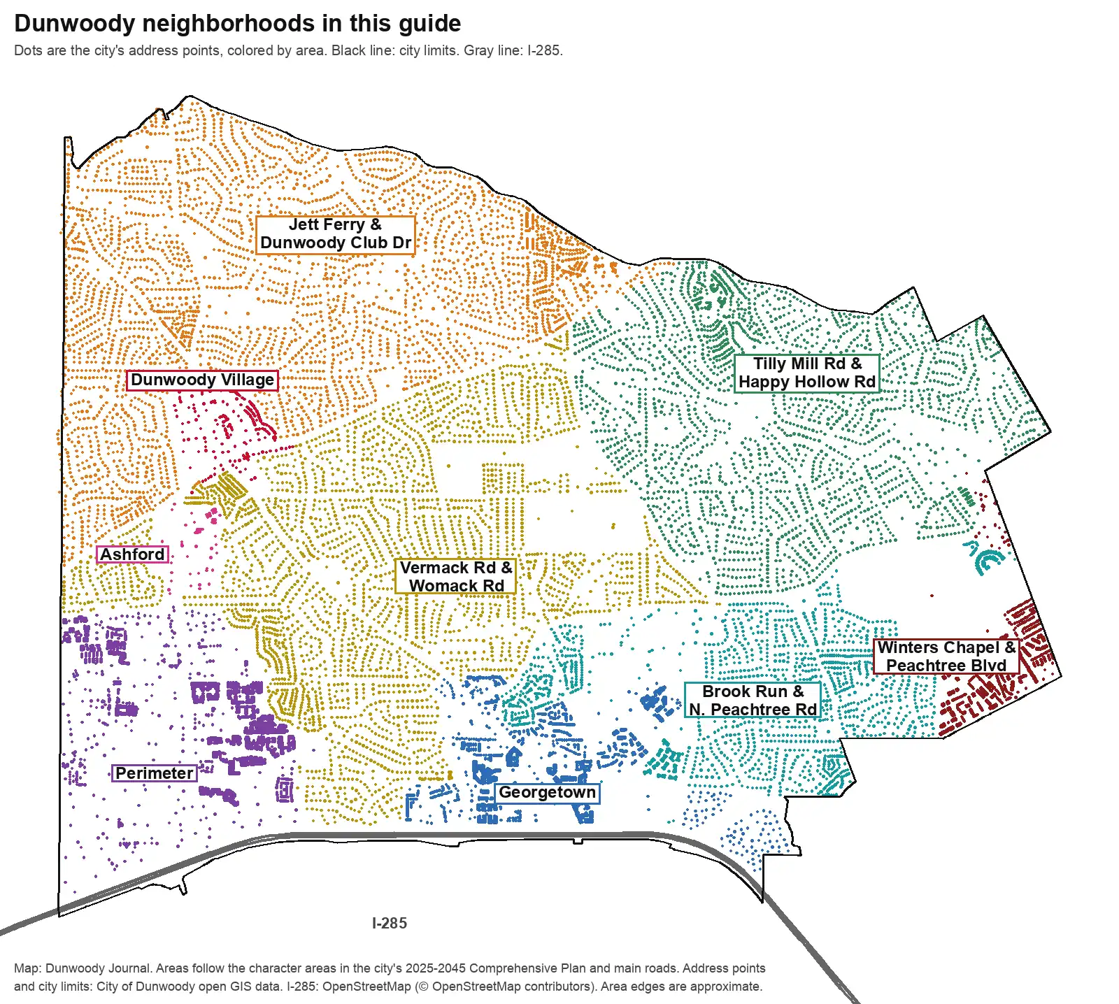
Map by Dunwoody Journal. Areas follow the character areas in the city’s 2025-2045 Comprehensive Plan and the main roads it names; address points and city limits are from the City of Dunwoody’s open GIS data, and I-285 is from OpenStreetMap, © OpenStreetMap contributors. Area edges are approximate.
The west side
Perimeter. The city’s high-rise corner north of I-285 and east of Georgia 400, with Perimeter Mall, MARTA’s Dunwoody Station and most of the city’s apartments. The plan counts 5,276 housing units and 21,779 jobs here.
Ashford. Upper Ashford Dunwoody Road between Perimeter and the Village, with City Hall, offices, condos and apartments. The 2025 plan split it off from Perimeter.
Dunwoody Village. The shopping district built from the early 1970s at Chamblee Dunwoody and Mount Vernon roads, with the library, the arts center and the Dunwoody Farmhouse. The plan wants it to become “Downtown Dunwoody.”
The neighborhoods
Jett Ferry and Dunwoody Club Drive. Everything north of Mount Vernon Road: more than 120 subdivisions, the Dunwoody Nature Center and Austin Elementary on Roberts Drive, and the small Jett Ferry shopping crossroads on the Sandy Springs line.
Vermack Road and Womack Road. Central Dunwoody, with Dunwoody High, Dunwoody and Vanderlyn elementaries, Georgia State’s Dunwoody campus, the Marcus Jewish Community Center and Homecoming Park.
Tilly Mill and Happy Hollow roads. The northeast side, east of Tilly Mill Road, almost all zoned for Kingsley Elementary, with Windwood Hollow and Waterford parks.
Brook Run and North Peachtree Road. South of Peeler Road around 110-acre Brook Run Park, with Chesnut Elementary and Peachtree Middle on North Peachtree Road.
Along I-285 and the east edge
Georgetown. The southern gateway at exit 30, with apartments, condos, office parks and shopping centers, Georgetown Park and Pernoshal Park. The plan calls for a new master plan here.
Winters Chapel and Peachtree Boulevard. The east edge on the Peachtree Corners line: a small crossroads at Winters Chapel and Peeler roads, DeKalb’s water treatment plant and older apartments along Peachtree Boulevard. All ZIP 30360.
Comparing Dunwoody with its neighbors
Taxes, schools, home values and commutes for Dunwoody and its three nearest city neighbors, side by side: Dunwoody vs. Sandy Springs vs. Doraville vs. Chamblee. For the citywide market, see our home prices guide; for every school, our schools guide. Taxes: our property tax guide. Getting set up: moving here.
How we built this
We named only areas a public source places on a map. The sources were:
- The city’s plan. The 2025-2045 Comprehensive Plan, passed by the City Council on Oct. 14, 2025, according to Rough Draft Atlanta, and filed with the Georgia Department of Community Affairs, which publishes the PDF. Its 11 character areas are Suburban Neighborhoods, Perimeter, Dunwoody Village, Georgetown West, Georgetown East, Winters Chapel, Jett Ferry, Ashford, Peachtree Boulevard, Civic Campus and Water Works. We combined Georgetown West and East; Winters Chapel, Peachtree Boulevard and Water Works; and Civic Campus with the neighborhoods around it.
- Main roads. The plan does not divide the Suburban Neighborhoods, so we split them along Mount Vernon Road, Tilly Mill Road and Peeler Road, roads the plan names, and named each part for its main roads.
- The city’s GIS data. The city’s open data has its character area map, city limits, 23,777 address points and a map of named subdivisions, apartments, condos and townhomes, which is where the neighborhood names on each page come from.
- School zones from the DeKalb County School District’s 2026-27 school locator map service, matched to every address point.
We found no homeowners association list published by the city, so these pages do not list HOAs. Area edges between plan districts follow main roads and are approximate; the district’s locator and DeKalb County’s property records are the authority for any one address. Store data is © OpenStreetMap contributors.
Frequently asked questions
What are the neighborhoods in Dunwoody?
Our guide covers nine areas: Perimeter, Ashford, Dunwoody Village, Georgetown, Winters Chapel and Peachtree Boulevard, Jett Ferry and Dunwoody Club Drive, Tilly Mill and Happy Hollow roads, Vermack and Womack roads, and Brook Run and North Peachtree Road. The names come from the city’s 2025-2045 Comprehensive Plan and the main roads it names.
What ZIP codes are in Dunwoody?
Three main ones. In the city’s address data, 66% of Dunwoody addresses are in 30338, 19% in 30346 and 14% in 30360, with a few in 30350 along the Sandy Springs line.
What high school is Dunwoody zoned for?
Dunwoody High. Every address in the city’s address data, apart from a handful at the edges, falls in the DeKalb County School District’s Dunwoody High zone. The zone also reaches about 1.8 square miles beyond the city line to the southeast.
How many elementary schools serve Dunwoody?
Six. Dunwoody Elementary’s zone covers 41% of city addresses, Chesnut 17%, Kingsley 14%, Austin 14%, Vanderlyn 12% and Hightower 3%, in the district’s 2026-27 zone map.
Is Dunwoody on Georgia 400?
No. Georgia 400 runs just west of the city line in Sandy Springs. Dunwoody’s highway is I-285, with exits 29, 30 and 31 along its south side.
Have your say